Pipe dreams - making sense of the ground beneath our feet
6 min read
The Christmas period is usually a much-needed opportunity for politicians to relax and escape the demands of the day job.
The Christmas period is usually a much-needed opportunity for politicians to relax and escape the demands of the day job. But on Boxing Day last year, while the rest of us were having a lie-in, Jeremy Hunt was forced to get back to work. Was the Eurozone in crisis? Was a bank teetering on the edge of collapse?
Not quite. A major water main had burst in his South West Surrey constituency, leaving 200 homes without water. So the Chancellor did the only thing an MP in a marginal constituency can do – and spent the day not eating leftovers and falling asleep in front of Chicken Run, but helping his constituents. And thanks to his position in the government, he even got the chief executive of Thames Water on the phone, so he could gently encourage them to hurry up and fix the problem.
Not everyone, of course, can be quite so resourceful. But soon we may not need to have water company executives on speed dial, thanks to a new system being rolled out by the Geospatial Commission, part of the Department for Science, Innovation and Technology. And the hope is that it will make maintenance of our underground utilities both faster and safer.
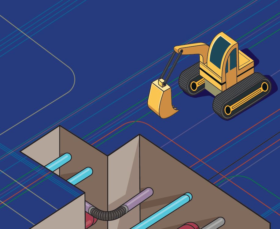
The National Underground Asset Register (NUAR) is, in essence, Google Maps for the world beneath our feet. Water mains, gas pipes, electricity wires, broadband cables and all the other invisible infrastructure that keeps society functioning will be mapped on the new system, which over the last few years has been piloted in the North East, Wales and London.
Last year, operations were expanded to cover the rest of England, with Northern Ireland to follow this spring. (The Scottish Road Works Commissioner has developed its own separate system, called Vault.)
There are multiple problems that NUAR is trying to solve. The first is that of speed. “If someone wants to carry out works in the road ... it’s on them to contact anyone who has, or may have had, assets in the area,” a policy official working on the project explains. “They then have to wait to get this data back, in order to carry out works safely; and this is received in different formats, scales and degrees of quality.”
In other words, digging up a road is a legal nightmare requiring a tonne of paperwork – and you have to start by figuring out which organisations actually own which underground assets in the first place (the government estimates that more than 700 different companies own infrastructure under the ground in England, Wales and Northern Ireland alone).
This means that maintenance can take a long time. As things stand, gathering this sort of data takes around six days of work. But logging on to NUAR, a user can simply navigate the map to where they want to dig, and they could conceivably have all the names, contact details and legal documents they need within seconds.
However, paperwork is far from the worst thing that can happen when digging up the roads. The real nightmare is accidental strikes – when, say, an electricity company digging up the road accidentally drills into a water pipe, which can both be legally and logistically tricky but also potentially life-threatening.
According to figures cited by the government, there are around 60,000 of these sorts of strikes every year – causing around £2.4bn worth of damage.
However, a quick check of NUAR should reveal a clear picture of exactly what lies beneath, before any shovels hit the ground. And as well as fewer accidental strikes, NUAR should provide an added layer of confidence for people digging up the roads in an emergency, when there may not be the time to formally check with asset owners what’s hiding underground before works begin.
“The biggest surprise to the public when we talk about this project is that something like this doesn’t already exist,” adds the policy official.
The biggest surprise to the public is that something like this doesn’t already exist
However, why it hasn’t been created until now quickly becomes clear when you realise that the difficulty isn’t building the digital map – but obtaining the data that feeds into it.
To draw the digital map, the team behind NUAR has spent the last few years trying to prise the asset datasets held individually by the utility companies out of their hands, and then wrangle that information into a common format so it all fits together digitally.
However, even when NUAR is fully operational, it will never be ‘finished’ – the map will be constantly evolving. The underground infrastructure in Britain will, of course, be constantly changing as pipes are laid and others are abandoned. The plan is that participating utilities will update NUAR when they dig up the road so that it always contains the latest data.
But there’s also the historic challenge. Because Britain’s infrastructure goes back decades, or in some cases even centuries, the unplanned mess exists underground and in physical filing cabinets. Different utility firms have maps of their own assets to varying levels of quality – some digital, some still on paper. And in some cases, utility owners may not even know the exact location of all the assets they maintain, until someone decides to send in a digger to check.
There is also the challenge of co-operation. Some utilities have been more forthcoming with their data than others – both for logistical reasons (see the aforementioned mess) and because, arguably, underground assets might be considered commercially sensitive.
That’s why, at the end of last year, the government laid down an amendment to the Data Protection and Digital Information Bill to toughen up utility companies’ data-sharing obligation.
Previously, the law said they had to share data, but it was very much an analogue law written in an era of paper documents. But following passage of the new law, firms will be obliged to share what they have digitally with NUAR. The same law also sets out a new system for payments to access the system, so that utilities firms will eventually pay for the maintenance of NUAR themselves. (The only downside is that we, the general public, won’t get to click around the utility map ourselves – as the government, understandably, doesn't want the locations of things like gas pipelines to be publicly accessible.)
The exciting news is that NUAR is now nearly fully operational. All of England and Wales are now covered, and the system is being operated in parallel with existing practices, so that companies and the government can test it. And once it is running, the estimate is that it will bring in an additional £490m every year of economic growth, from time saved, fewer asset strikes, and fewer disruptions to business.
So perhaps next time there is an emergency situation, like the one Jeremy Hunt found himself in over Christmas, NUAR will help maintenance teams figure out where to dig more quickly – so the water can continue to flow, and the Chancellor can finish eating his leftover turkey.
